
by Emmitt Barry, Worthy News Washington D.C. Bureau Chief
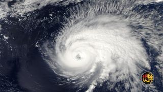
(Worthy News) – Hurricane Polo remained a formidable storm off Mexico’s Pacific coast Wednesday morning, carrying 150 mph sustained winds as its outer rainbands began reaching southwestern Mexico.
As of 6 a.m. Central time on September 23, the hurricane was approximately 165 miles south of Zihuatanejo and moving north at only 2 mph. The National Hurricane Center said Polo was expected to make a sharp turn toward the northwest before continuing generally west-northwest over the Pacific. The latest official advisory kept the hurricane offshore but dangerously close to Mexico’s coastline.
Mexico Faces the Immediate Danger
A tropical storm warning was in effect from Tecpan de Galeana to Punta San Telmo, while a tropical storm watch extended westward to Playa Perula. Communities elsewhere along southwestern Mexico were told to continue monitoring the storm because additional alerts could become necessary.
Forecasters expected 3 to 6 inches of rain across coastal Guerrero and Michoacán, with isolated totals approaching 8 inches. Coastal portions of Oaxaca, Colima and Jalisco could receive 2 to 4 inches.
That rain may fall over steep and vulnerable terrain, raising the prospect of sudden flooding and deadly mudslides. Polo-generated swells were also expected to produce life-threatening surf and rip currents along portions of Mexico’s southwestern coast. The National Hurricane Center identified flooding, mudslides and hazardous ocean conditions as the storm’s central threats. Official forecast discussions should remain the first source for changing conditions.
The storm carries particular emotional weight for families who remember Hurricane Otis. That hurricane rapidly intensified before devastating Acapulco in 2023. Polo also strengthened with startling speed, climbing from a 50 mph tropical storm to a Category 5 hurricane in roughly one day.
A NOAA Hurricane Hunter aircraft measured Polo’s peak sustained winds at 180 mph Tuesday afternoon and found its central pressure had fallen to 892 millibars. Those figures placed Polo among the most powerful hurricanes observed in the eastern Pacific in recent decades. The storm weakened overnight during an eyewall replacement cycle, but it remained an extremely dangerous major hurricane.
Copyright 1999-2026 Worthy News. This article was originally published on Worthy News and was reproduced with permission.